After the 2017 Jack Creek Fire, the Dam Safty Office (DSO) raised the hazard classification of the Eightmile Dam. Because the dam had already had maintenance issues, Icicle and Peshastin Irrigation Districts began developing alternatives to replace it. Initially, IPID developed several conceptual alternative design configurations for consideration by DSO. Through several discussions with DSO, IPID carried two alternatives forward: the narrow spillway with gates (Alternative 1) and the wide spillway without gates (Alternative 2). As a result of the EIS scoping process, a third action alternative was added for analysis in the EIS: the narrow spillway without gates (Alternative 3).
The three action alternatives and the No Action Alternative were evaluated in the EIS. The alternatives are described below.
The preferred alternative, Alternative 2: Wide spillway without gates
Alternative 2 includes replacement of the existing dam with an earthen embankment and reinforced concrete dam with a primary spillway length of 180 feet. The primary spillway will be fixed and completely passive. No gates or automated equipment will control the spillway or adjust the spillway crest elevation. This will result in a wider spillway and a larger footprint than the Narrow Spillway Alternative (Alternative 1). There will be no intermediate spillways. The primary spillway will have a hard spillway crest at an elevation of 4,671.0 feet.
During extreme storm events, the lake will flow over the entire length of the primary spillway. A secondary spillway, the same as the Narrow Spillway Alternative, will be created in a low spot south of the main dam structure by hardening an existing channel with rock and riprap. The secondary spillway will have a crest elevation of 4,673.0 feet. The spillways will provide enough capacity to pass the design storm event while maintaining the freeboard in the lake required by DSO.
As with the Narrow Spillway Alternative, water will be released from the lake through a new 30-inch diameter low-level outlet pipe/siphon. The operation and configuration of the low-level outlet pipe will be the same described for the Narrow Spillway Alternative, with the low-level outlet pipe located entirely within the Special Warranty Deed Area.
The low-level outlet valve at the lake will be powered by batteries charged by a solar panel. Lake levels, valve positions, and other controls will be monitored remotely, and the equipment will be operated via radio signal requiring an antenna, which will be located at the dam site. The controls and monitoring equipment will be concealed as much as possible.
Other alternatives that were considered
No Action Alternative
The No Action Alternative is the baseline against which the action alternatives are evaluated and compared. It illustrates the most likely scenario if the project is not implemented. Analysis of the No Action Alternative is required under SEPA (WAC 197-11-440 (5)(b)(ii)).
Under the No Action Alternative, the existing dam would be left as is, and it would continue to operate in its current state and manner, with a primary spillway elevation of 4,667 feet and an outlet pipe that allows drawdown of the lake to a water surface elevation (WSEL) of approximately 4,640 feet without pumping. The invert elevation of the low-level outlet pipe is 4,648.7 feet, but additional drawdown occurs after the lake WSEL has reached the elevation of the low-level outlet pipe due to seepage through the landslide deposits that underlie the dam. Seepage can draw the lake down to a WSEL of 4,640 feet without pumping. The DSO considers the dam vulnerable in the event of a large storm due to changed conditions in the watershed both upstream and downstream of the dam, as well as to the condition of the dam itself. The Jack Creek Fire in 2017 burned a significant forested area in the watershed, creating conditions that generate higher peak runoff rates to the lake.
Operation of the dam under existing conditions is not consistent with DSO regulations and does not meet the DSO’s safety requirements for a High Hazard Dam. The DSO would eventually exercise enforcement actions in accordance with WAC 173-175-620 (3). However, it is not possible to predict with certainty what that action or its effects would be. DSO currently requires IPID to leave the low-level outlet open during the winter and early spring to reduce the risk of a dam failure. Consequently, for purposes of this EIS analysis, it is assumed that the existing state of the dam and its operation remain unchanged.
The No Action Alternative does not meet IPID objectives for water storage capacity for operations and irrigation water delivery. It would not contribute to the IWG Guiding Principle 1 related to streamflow improvements. The dam is currently operating in a deteriorating and unsatisfactory condition. An estimated 150 downstream residences are at risk if the existing dam were to fail, resulting in a High Hazard Classification.
Alternative 1: Narrow spillway with gates
Alternative 1 includes replacement of the existing dam with an earthen embankment and reinforced concrete dam structure equipped with automated control gates over the primary spillway. Three 4-foot-high, 20-foot-long automatic level control gates would be installed on top of the primary spillway, which would have a hard crest elevation of 4,667 feet. The gates would allow IPID to control the water level within the top 4 feet of the lake. When additional water supply is needed, IPID would raise the gates in the late spring or early summer to raise the lake to elevation 4,671 feet prior to releasing the water in the late summer. The gates would automatically lower if the lake level gets too high to protect the dam and prevent overtopping. For example, if a storm occurs when the gates are up and the lake is full, the gates would automatically lower to pass peak flows generated by the storm. This design would allow for a narrow primary spillway (60 feet wide) and therefore a smaller dam footprint compared to the Wide Spillway Alternative (Alternative 2).
During extreme storm events, the lake would continue to rise above the primary spillway. Two 15-foot-wide intermediate spillways on either side of the primary spillway would provide 30 feet of additional spillway width at an elevation of 4,671.5 feet. A secondary spillway would be created in a low spot south of the main dam structure by using rock and riprap to harden an existing channel. The secondary spillway would have a crest elevation of 4,673 feet. The spillways would provide capacity to pass the design storm event required by DSO (a storm that has the probability of occurring once in 1,000,000 years) while maintaining the freeboard (the vertical distance of the crest of the dam above the maximum lake water level) in the lake required by DSO.
Water would be released from the lake through a new 30-inch diameter low-level outlet pipe/siphon. The low-level outlet pipe/siphon would extend from an inlet submerged in the lake approximately 150 feet west of the new dam structure to an outlet in the Eightmile Creek channel approximately 314 feet downstream of the new dam structure. This would allow the lake to be drawn down to a low-water surface elevation of 4,636 feet, which would allow access to stored water without pumping. The low-level outlet pipe would be located entirely within the Special Warranty Deed Area. IPID would release water during the late summer to maintain the water supply available for irrigation use and instream flows in Icicle Creek. Releases through the low-level outlet pipe would be controlled by an automated plug valve at the downstream end of the pipe. IPID would have the ability to adjust the valve remotely to release the flows needed to meet downstream IPID water supply needs and instream flow needs.
The primary spillway gates and low-level outlet valve at the lake would be powered by batteries charged by a solar panel. Lake levels, gate and valve positions, and other controls would be monitored remotely, and the equipment would be operated via radio signal requiring an antenna, which would be located at the dam site. The controls and monitoring equipment would be concealed as much as possible.
Alternative 3: Narrow spillway without gates
Alternative 3 was developed as a result of comments received during scoping that suggested that the EIS should include an alternative dam design that matches the existing spillway elevation of 4,667 feet.
Under Alternative 3, the dam type and configuration would be almost identical to that of Alternative 1, having a narrow spillway and a concrete spillway apron, but with no mechanical gates. The mechanical gates that are included as part of Alternative 1 would allow IPID to store up to a maximum water surface elevation of 4,671 feet with the gates activated. Alternative 3 would have no gates and would be designed to store water only up to a maximum water surface elevation of 4,667 feet. This alternative would have the same footprint as Alternative 1. Because Alternative 3 would not have mechanical gates, the primary spillway would include one continuous 60-foot-wide primary spillway section with a crest elevation of 4,667 feet. The intermediate and secondary spillways for Alternative 3 would be identical to that described for both Alternatives 1 and 2.
The maximum volume of water that could be stored for release by the dam would be less with Alternative 3 than for the other two action alternatives. Alternative 3 would not meet all of IPID’s objectives because there would be less potential water storage available for release to ensure against drought conditions. Because there would be less potential water available during drought conditions, this alternative may require pumping to access more than 1,698 acre-feet of water storage.
As with Alternatives 1 and 2, the low-level outlet valve at the lake would be powered by batteries charged by a solar panel. Lake levels, valve positions, and other controls would be monitored remotely, and the equipment would be operated via radio signal requiring an antenna, which would be located at the dam site.
Construction methods – applicable to all action alternatives
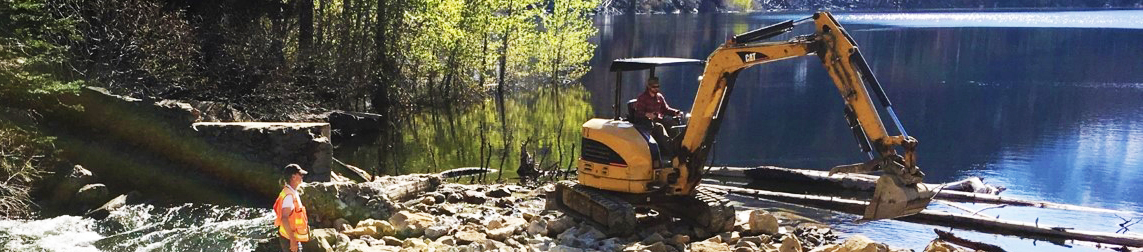
Constructing the dam would require transporting equipment and materials into and out of the Special Warranty Deed lands within the Alpine Lakes Wilderness. There are no roads that directly access Eightmile Lake. The lake can be accessed on-foot via the Eightmile Lake Trail (Forest Service Trail #1552), which IPID uses for routine maintenance at the dam. The trailhead is accessible from Leavenworth by vehicle following Icicle Road and FSR 7601-116. The distance from the trailhead to the lake is about 4 miles. An estimated 4 to 6 construction personnel per week will likely use the upper portion of this trail for access to the site on foot, although some may choose to hike from the trailhead. IPID proposes to improve and reopen a portion of a currently closed road located outside of the Alpine Lakes Wilderness for administrative use to bring vehicles closer to the project site.
Helicopters would be used to move all equipment and the majority of materials to and from the site on Special Warranty Deed land. The primary determinant of the type of helicopter to be used is the maximum weight that needs to be transported. The largest payload would be the excavator, which could be partially disassembled to aid in transport and reassembled on-site.
Two approaches to helicopter use were considered.
Preferred - Option 1 would use the larger helicopter to transport nearly all equipment and material to the site at the beginning of the project, followed by a limited number of additional trips using the smaller helicopter to bring materials that were not anticipated initially.
Option 2 would involve the limited use of the large helicopter to move only the heavy equipment and a portion of the material, followed by periodic delivery of materials as needed throughout the construction, using the smaller helicopter. Under both options, the large helicopter would be used for 1 to 2 days to remove equipment and any remaining materials at the end of construction. It is anticipated that the majority of the helicopter trips would occur on weekdays; however, some weekend flights may be necessary.
Please note that option 1 is preferred for helicopter use in order to minimize the total number of helicopter trips, but ultimately this will be dependent on large helicopter availability during wildfire season that will also overlap with the construction period.