

Air monitors around Washington state are lighting up the maps like a Christmas tree – and red lights aren't good.
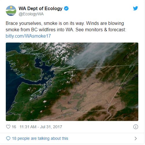
Almost every community in the state has been hit hard by smoke blowing in from British Columbia wildfires. You can see it, you can almost reach out and touch it, and many of us are feeling it.
If you look at air quality across the U.S., Washington has had the worst readings since the wildfire smoke hit the state earlier this week.
Air quality monitors in the U.S.
Monitors hitting high readings like never before
Mike Ragan, Ecology's air monitoring coordinator, took a snapshot of air pollution values across the state early Thursday and found high levels of particle pollution everywhere.
"We've never seen numbers like this across the board," said Ragan. "When the state's cleanest air monitor hits very high levels of pollution, you know it's bad."
Department of Ecology air quality network on Aug. 3. The dots represent an air quality monitor. See the corresponding legend for air quality values. 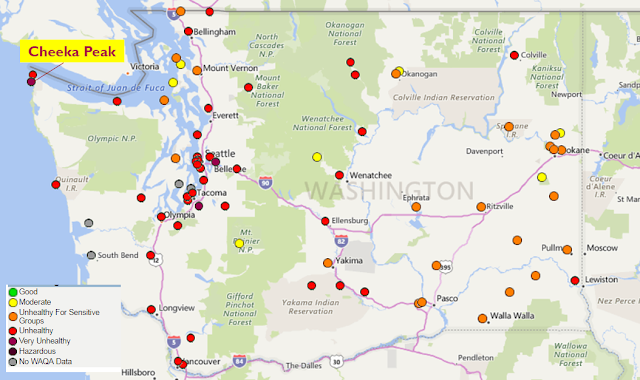
In Washington, it's not uncommon for some parts of the state, usually Central and Eastern Washington, to reach unhealthy levels of air pollution during a wildfire. What's different about the current scenario is that the entire state has been blanketed by a thick layer of smoke and Western Washington in particular is socked in.
In the air pollution world, a daily average of up to 12 micrograms of particle pollution per cubic meter is considered in the healthy range. Anything over that has varying levels of health impacts:
- 0 – 12 Good
- 13 – 19 Moderate
- 20 – 34 Unhealthy for Sensitive Groups
- 35 – 80 Unhealthy
- 80 – 135 Very unhealthy
- Over 135 Severe impacts
Even what is typically the state's cleanest air, measured at the monitor on Cheeka Peak near Cape Flattery on the Olympic Peninsula, is showing signs of the smoke.
"Last year at this time, Cheeka Peak read 1 microgram per meter. This morning, it had a reading of 208," Ragan said. "Cheeka Peek is near a shipping lane on the coast. That's not where we expect to see dense air pollution."
While the numbers Ragan captured were not the daily averages, they represent the bigger picture: It's hard for people to breathe.
Below is the snapshot of readings Ragan took Thursday morning:
| Monitor location | Air pollution PM 2.5 values* |
|---|---|
| Cheeka Peak | 208 |
| Lacey | 80 |
| Port Angeles | 130 |
| Puyallup | 132 |
| Tacoma | 149 |
| Twisp | 183 |
| Winthrop | 176 |
| Omak | 132 |
| Chehalis | 117 |
| Spokane | 53 |
| Seattle/Duwamish | 102 |
We saw it coming, but who knew it'd be this bad?
Forecasters at Ecology tried to prepare people for the hit, issuing warnings beginning on Monday about the expected smoke, but they didn't know it would land this hard.
"We knew a lot of smoke would transport from the B.C. fires, but this really is unprecedented," said Ranil Dhammapala, an Ecology atmospheric scientist.
If you can see it and feel it, don't go in it
So what can you do? You can always check state air quality monitors to determine what the air quality levels are, but a good rule of thumb is if you can see the smoke, stay inside. Health departments and toxicologists are urging people to forego strenuous outdoor activities. Now's not the time to get that really awesomely-hard park workout in or work on your best 10K time. Stay inside. Wait it out. Mow your lawn another day.