Official websites use .gov A
.gov website belongs to an official government
organization in the United States.
Secure .gov websites use HTTPS A
lock (
) or https:// means you’ve safely connected to
the .gov website. Share sensitive information only on official,
secure websites.
The Nooksack and Sumas Transboundary Flood Initiative
The Transboundary Flood initiative (TFI) uses a collaborative framework to identify and pursue actions to reduce flood risk and restore habitats.
Floodwaters do not recognize borders. Repeated flooding from the Nooksack River in Whatcom County into the Sumas Prairie in British Columbia is a shared challenge on both sides of the US/Canada border. The flood events in 1990 and 2021 demonstrate that flood risk in the transboundary area of the Nooksack and Sumas watersheds is not an issue that any one government or First Nation can solve alone.
Each jurisdiction has unique priorities, perspectives, and authorities regarding flood mitigation in the transboundary area. We will be more effective by working together through the TFI.
Who’s involved
The nine partners to the collaborative framework are:
The Initiative’s nine partners are committed to jointly:
Advancing flood risk reduction and ecosystem restoration strategies
Sharing data
Leveraging funding opportunities to support flood mitigation projects in the transboundary area
The State of Washington and the Province of British Columbia help to facilitate and coordinate the work of the Initiative. The TFI partners signed the Collaborative Framework (the framework) in October 2023. The framework will remain in effect for an initial period of four years. The partners anticipate renewals as solutions are advanced.
Planned initial work of the TFI is:
Updating and aligning hydraulic models and improving flood forecasting
Understanding flood risk and impacted communities on both sides of the border
Understanding uncertainty and factors affecting flood risk throughout the Nooksack and Sumas watersheds
Developing joint values and objectives that communicate the varied interests and shared goals represented by the Initiative
Looking for solutions that advance ecosystem restoration and mitigate flood risk
Incorporating Traditional Ecological Knowledge into solutions where appropriate
Creating durable solutions for adapting to climate change
Structure of TFI tables
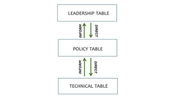
The framework includes three tables that work at different levels to develop solutions. Each table works together to address flooding concerns and ecosystem restoration. The three tables are:
Leadership Table
Technical Table
Policy Table
The three tables work collectively to advance:
Policy recommendations
Values-based discussions
Technical solutions
Leadership Table
The Leadership Table includes elected leaders or representatives of government agencies from each of the nine parties. This table:
Provides high-level coordination of priorities and needs
Directs the Policy and Technical Tables to investigate topics
Provides guidance to the Policy and Technical Tables when issues arise
Meets two to three times per year
Policy Table
The Policy Table includes policy or department staff from each of the nine partners. This table:
Discusses values-based issues and develops solutions to bring to the Leadership Table
Requests more information from the Technical Table as needed
Meets every other month
Technical Table
The Technical Table is made up of flood managers, scientists, and subject-matter experts. The table:
Discusses technical information, such as sediment and river modeling and climate change data
Works collaboratively with the Policy Table
Receives direction from the Leadership Table to develop reports and plans
Fosters collaboration between the Floodplain Integrated Planning work group in Whatcom County and the Sumas River Watershed Flood Mitigation Plan work group in B.C.
Meets every other month
The TFI is just one aspect of work to build flood resilience and restore habitat on both sides of the border. Local initiatives within the Sumas and Nooksack watersheds develop proposals and on-the-ground projects for flood risk reduction and habitat restoration, and TFI provides a venue for signatory parties to pursue greater alignment of these local initiatives and maximize benefits throughout the watershed.
These proposals and other on-the-ground projects are being developed in parallel, using shared data about flood management priorities and risks to reduce conflicts among the projects. They are led by local partners, First Nations, and Tribes:
Project planning for Barrowtown Pump Station is underway following a $76.6 million investment from the Province of B.C. for completion in 2027. One of the components is a floodwall to protect the Barrowtown Pump Station, and this work starts in early 2025.
A backup power generator is being installed at Barrowtown Pump Station, to maintain pumping operations and increase flood resiliency in the event of a power failure. Installation is expected to be complete by the end of 2024.
Bank stabilization and dike erosion repairs along Sumas River have been completed.
Participants include the Whatcom County Flood Control Zone District, Lummi Nation, Nooksack Indian Tribe, Ag Water Board, the cities in the Nooksack River floodplain, and Ecology.
The River and Flood Division has secured grants for voluntary property buyouts and home elevations in areas at high risk of repeated flooding, including $9.4 million for 12 acquisitions and $2.4 million for 12 home elevations.
One of the Initiative’s goals is to create a common technical understanding on both sides of the border, using shared data on conditions, land use, priorities, and risks. This common understanding will provide a framework for local decision making, guiding projects that will integrate flood management and habitat restoration approaches.
Technical milestones reached in the first year of the Initiative include:
Alignment of the US and Canadian hydraulic models – These computer models predict where floodwaters will go and what their impacts may be. Previously they did not reflect information from the other side of the border, and did not use the same data. They are now consistent with each other and are able to share data and projections.
Improved flood warning – The Nooksack River is a very dynamic river due to the large amount of sediment carried from its headwaters in the North Cascades. The depth of its riverbed is constantly changing, making it a challenge to accurately forecast floods. The National Weather Service worked with Initiative partners on both sides of the border to improve the flood forecasting protocols, resulting in new flood impact statements and flood warning bulletins for the Everson Overflow Corridor.