Centralia –
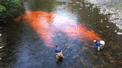
Starting around dusk Aug. 6 and 7, Department of Ecology scientists will release pink Rhodamine dye at four Lewis County locations on the Chehalis River to better understand how long water takes to travel down the river.
Ecology’s Office of Chehalis Basin is tasked with financing and implementing projects that support the long-term Chehalis Basin Strategy to protect communities, families and livelihoods in the flood-prone watershed while restoring habitat for salmon, steelhead and other aquatic species.
The tests will help Ecology calibrate and validate a water quality model for the river, an integral part of developing the overall strategy to reduce damages from floods while restoring aquatic habitat in the 2,700 square-mile basin.
During the past 30 years, the Chehalis basin has suffered its five largest floods in recorded history, resulting in millions of dollars in damage. At the same time, fish resources in the state’s second-largest river drainage system have been in steep decline.
The dye used in next week’s study will not harm animals, fish, plants or people and is only visible to the human eye for about a mile downstream from the release sites. Testing is being done in the evening to keep disruptions to activities on the river to a minimum.
Scientists will use the dye tests to understand how fast the water moves in different areas of the Chehalis River. This information is critical in order to simulate temperature and dissolved oxygen levels during critical summer conditions.
Researchers will track the dye plume with a fluorometer, which detects small amounts of dye in the river even after it is no longer visible. They will also use electronic probes to gather stream data.
On Monday, Aug. 6, scientists will release dye at the confluence of the Chehalis and Skookumchuck rivers at Fort Borst Park in Centralia and at Lintott/Alexander Park in Chehalis where the Newaukum and Chehalis rivers converge.
The evening of Tuesday, Aug. 7, researchers will release dye to the river at Pe Ell where State Route 6 crosses the Chehalis River and in the canyon between Ceres and Adna located just north of State Route 6 about one-half mile downstream where the south fork of the river joins the main Chehalis River channel.
The Chehalis River drainage basin – or watershed – starts in Lewis County south of Pe Ell, crosses Thurston and Grays Harbor counties and empties to Grays Harbor on the Pacific Ocean. The basin includes the Chehalis, Newaukum, Satsop, Skookumchuck and Wynoochee rivers as well as numerous other streams and rivers.
Department of Ecology News Release - August 3, 2018
Scientists to conduct dye tests in Chehalis River
Next week's water quality study helps advance Chehalis Basin Strategy