

Oil transportation risk assessments and studies
Washington is experiencing rapid changes in the types of crude oils that are moving through the state, the methods used for oil transportation, and the locations where crude is moved. A major oil spill or fire could have severe consequences to public safety, the environment, local economies, and overall quality of life.
Our risk assessments help prepare and plan for response to oil-related incidents that could impact major waterways. By evaluating when and how oil moves through the state and the associated risks, we can make recommendations for cost-effective spill prevention measures while protecting public health and safety, the state's economy, and the environment.
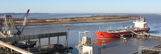
Grays Harbor Vessel Traffic Risk Assessment (GHVTRA)
The Grays Harbor Vessel Traffic Risk Assessment, completed in December 2018, follows similar risk assessments we’ve completed for the Columbia River and Puget Sound.
- Vessel Traffic Risk Assessment — focus sheet (summary)
- Vessel Traffic Risk Assessment — full report
- Response Capacity Analysis — full report
GHVTRA goals:
- Assess baseline and changing oil spill risks
- Identify measures that could help reduce the risks of oil spills
- Assess oil spill response preparedness
- Identify baseline oil spill response capability
Why it matters
Around 100 deep-draft commercial vessels call on Grays Harbor each year. It is the home of a significant commercial and Tribal fishing fleet and one of the most valuable commercial fishing operations on the West Coast. Nearby Grays Harbor National Wildlife Refuge is one of four major staging areas for shorebirds in North America. A major spill here could have severe consequences to the environment, economy, public health, and cultural and historical resources.
Benefits of a risk assessment
Vessel traffic risk assessments help local communities prepare and plan for a response to oil-related incidents that could impact major waterways. Our participation adds value because we know when and how oil moves through the state and the associated risks, so we can recommend cost-effective spill prevention measures locally.
Our process
We began this work in 2017, working closely with Tribes, local, state and federal partners, and environmental groups. We used the International Maritime Organization Formal Safety Assessment process to conduct the assessment. We facilitated two workshops to complete Hazard Identification, the first step in Formal Safety Assessment. During the Hazard Identification workshops, participants identified local factors related to oil spill risks, reviewed safeguards currently in place, and discussed recommendations that could improve spill prevention for commercial vessel traffic.
Building on the Hazard Identification outcomes, we met with governments and stakeholders to discuss a follow-on project, which will assess oil spill response preparedness in Grays Harbor. We also held a workshop for commercial and Tribal fishermen and recreational boaters. This workshop provided an opportunity to identify practices for improving safety and preventing oil spills from smaller vessels.
Columbia River Vessel Traffic Safety Assessment (CRVTSA)
Working with Tribes, government agencies, stakeholders, and nongovernmental organizations, we conducted an evaluation of vessel traffic management and vessel traffic safety for the Columbia River. We provided our report to the Legislature in November 2017.
More information
- Focus on Columbia River Vessel Traffic Evaluation and Safety Assessment (CRVTSA). Get a quick overview of this project.
- Report to the Legislature on the CRVTSA. Read the report.
Salish Sea Risk Mitigation Workshop
At our January 2015 Salish Sea Workshop, participants identified seven categories of risk for oil spills associated with vessel traffic patterns in the Salish Sea. Within each category, participants identified specific risk factors and began the process of identifying mitigation measures to address each risk factor. The 2016 workshop expanded on this effort, incorporating new information from studies and projects since January 2015.
More information
- Focus on 2016 Salish Sea Risk Mitigation Workshop. A quick summary of the workshop.
- 2016 Salish Sea Workshop report. Details on the workshop.
2015 Vessel Traffic Risk Assessment (VTRA)
Strait of Juan de Fuca, Puget Sound, San Juan Islands and connecting waterways
We sponsored development of the 2015 Vessel Traffic Risk Assessment, which provides updated information about the risks of oil spills from commercial vessel traffic currently operating on the Salish Sea. It also models potential impacts from planned future developments, as well as potential benefits from applying a variety of spill prevention measures.
George Washington University and Virginia Commonwealth University conducted the assessment for us, along with a work group of representatives that provided guidance from government, Tribal, industry, and environmental organizations.
This updated assessment is based on 2015 vessel traffic data, and builds upon previous assessments that incorporated vessel traffic data from 2005 and 2010.
More information
- Focus on 2015 VTRA Final Report. Get a quick overview of this project.
- 2015 VTRA Final Report. Get the executive summary and details on this risk assessment.
2014 Marine and Rail Oil Transportation Study
We received one-time funding in 2014 to conduct a Marine and Rail Oil Transportation Study. The study analyzed the risks to public health and safety, and the environmental impacts associated with the transport of oil in Washington state.
We worked with several partners to complete the study, including Washington Utilities and Transportation Commission; Emergency Management Division; Tribes; other federal, state, and local agencies; informal and formal public and private committees; organizations; industry; and the public.
More information
- Focus on the 2014 Marine and Rail Study — quick summary of the study's results.
- 2014 Marine and Rail Oil Transportation Study — analyzes risks and impacts associated with the transportation of oil in Washington.
- Frequently heard comments — comments received during the study from stakeholders and the public.
Contact information
Brian Kirk
Prevention Section Manager
brian.kirk@ecy.wa.gov
425-395-5800