Late winter precipitation boosts water supply for summer
Continued cold, snowy weather during late winter brought the good news needed for this summer’s water supply. As the weather becomes more spring-like, Washington’s snowpack levels are near or above normal for this time of year.
Statewide snowpack
Across the state, the snow supply average is 119 percent of normal. That number is a big WOW for farmers, fish managers, and water users in cities and towns, as they breathe a sigh of relief.
Earlier water supply forecasts contemplated lean snow levels in the Walla Walla Basin, but heavy March snow improved the basin-wide snowpack to 111percent of normal. The lower Snake River snowpack is particularly flush at 124 percent of normal.
The lower Columbia region — consisting of the Cowlitz, Lewis, and Washougal watersheds — recovered to 108 percent of normal from 88 percent in late February. The upper and lower Yakima River Basin are at 101 and 103 percent of normal, respectively. The Olympic Mountains (119 percent of normal), north Puget Sound (124 percent of normal), upper Columbia basins (143 percent of normal) all have healthy snowpack.
In time for early spring and irrigation season, there is ample mountain snowpack and cool temperatures forecasted by the Climate Prediction Center for the immediate future.
One area of minor concern that the snowpack is nearing saturation point, and heavy precipitation may initiate faster melt off.
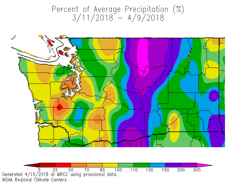
Although some spots were dry March 11-April 9, the Cascades and north central WA received ample precipitation.
Precipitation
Precipitation at mountain SNOTEL sites since the beginning of the water year is 112 percent of normal. Puget Sound headwaters stations range from 105 percent of normal at Stampede Pass, to 140 percent of normal at Huckleberry Creek. Both the upper and lower Yakima basins are at 108 percent of normal for precipitation.
Statewide precipitation over the previous 30 days is slightly below normal in Western Washington, and average in Eastern Washington. The last seven days, however, have been near or above average for the state (including non-mountain areas).
The precipitation outlook for the near term is for above normal precipitation through spring.
The U.S. Drought Monitor indicates there is no data suggesting drought for portions of Yakima and Klickitat counties in south central Washington. Most states to the south of Washington are experiencing some drought, ranging from Abnormally Dry to Exceptional Drought in Oklahoma.
Temperature
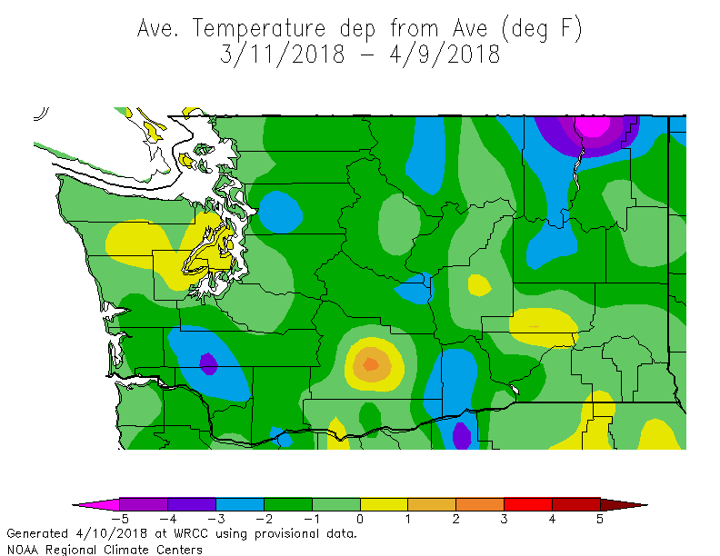
Temperatures in Washington have been near-normal statewide, averaged over the previous 30 days. The Climate Prediction Center forecasts below normal temperatures for both the next two weeks and normal temperatures for the remainder of spring. Cooler temperatures aide the water supply outlook by regulating the rate snow melts and discharges into rivers.
Yakima County was the only real hotspot for temps March 11 to April 9
Streamflows
Looking ahead to this summer, both the Natural Resources Conservation Service and National Weather Service are forecasting that we are likely to have normal to above-normal water supplies this year.
For water supply purposes, the April to September runoff period is critical because this is when water demand is highest, but precipitation is lowest, hence our scrutiny of snowpack and reservoir levels.
This year, forecasted runoff for this period is above 100 percent of normal in all but one or two locations. In fact, some locations in the Upper Columbia River Basin (e.g., Kettle, Okanogan, Methow Rivers) have forecasted runoff in excess of 125 percent of normal, which may portend flooding.
We’ll continue to keep tabs on streamflows through the spring and summer.
Irrigation and storage reservoirs
In the Yakima River Basin, the U.S. Bureau of Reclamation operates five reservoirs to store water for agriculture irrigation and fishery purposes. At this point, total system storage (all five reservoirs considered together) is 119 percent of average or about 818,000 acre feet. Total storage capacity is a little over one million acre feet. Reclamation forecasts that they will be able to meet 100 percent of water supply to users of project water this year. The bureau will update its forecast in early May
On the west side, the City of Seattle stores water on the Cedar and South Fork Tolt rivers. Snowpack is continuing to build and is above the long-term median for this time of the year. Snowpack in Seattle’s mountain watersheds typically reach peak accumulations around the first week of April. Storage is also above long term median conditions.
Beginning-of-month storage conditions for other reservoirs in Washington state are available at the NRCS interactive mapping tool.


