

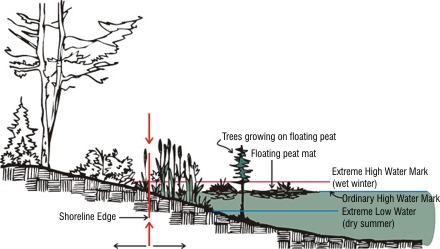
Ordinary high water mark
Under Washington's Shoreline Management Act, the ordinary high water mark (OHWM) is defined as a biological vegetation mark. For locations where the OHWM cannot be found, our Shoreline Master Program guidelines include default elevation lines for tidal and freshwater shorelines.
Definition
The ordinary high water mark is defined as:
"Provided, that in any area where the ordinary high water mark cannot be found, the ordinary high water mark adjoining salt water shall be the line of mean higher high tide and the ordinary high water mark adjoining fresh water shall be the line of mean high water."
- Accretion
- Activities of beavers and other animals and organisms
- Consistency of pool elevations
- Erosion
- Groundwater
- Land-use changes
- Presence of peat
- Soils
- Stormwater runoff
- Substrates
- Waves
- Wind
Related links
Contact information
Central Regional Office:
Chelan and Okanogan counties
Mike Locatelli
Michael.locatelli@ecy.wa.gov
509-379-4541
Benton, Kittitas, and Yakima counties
Ryan Anderson
ryan.anderson@ecy.wa.gov
509-379-1917
Douglas and Klickitat counties
Heather Durkee
Heather.Durkee@ecy.wa.gov
509-379-4530
Eastern Regional Office:
Adams, Grant, Lincoln, & Whitman counties
Jake Madewell
Jake.Madewell@ecy.wa.gov
509-437-0255
Asotin, Columbia, Franklin, Garfield, Spokane, and Walla Walla counties
Mindi Sheer
Mindi.Sheer@ecy.wa.gov
509-601-9546
Ferry, Pend Oreille, & Stevens counties
Ryan McNair
Ryan.McNair@ecy.wa.gov
509-309-5547
Northwest Regional Office:
King County
Leah Beckett
leah.beckett@ecy.wa.gov
425-324-5590
Neil Molstad
neil.molstad@ecy.wa.gov
425-389-5549
Snohomish county
Doug Gresham
doug.gresham@ecy.wa.gov
425-429-1846
Island county
Leah Beckett
leah.beckett@ecy.wa.gov
425-324-5590
Kitsap county
Neil Molstad
neil.molstad@ecy.wa.gov
425-389-5549
Whatcom, San Juan, and Skagit Counties
Chris Luerkens
chris.luerkens@ecy.wa.gov
360-410-4807
Southwest Regional Office:
Clallam, Jefferson, and Thurston counties
Lizzie Carp
lizzie.carp@ecy.wa.gov
564-200-4184
Pacific, Grays Harbor, and Lewis counties
Zach Meyer
zach.meyer@ecy.wa.gov
360-481-9885
Clark, Cowlitz, and Skamania counties
Meghan Flounlacker
Meghan.Flounlacker@ecy.wa.gov
360-210-2783
Pierce, Mason, and Wahkiakum counties
Brook Swensen
Brook.swensen@ecy.wa.gov
564-999-1749