

Basin resident Mike Smell lives on the Newaukum River near Chehalis. During floods, he moves his equipment to high ground and has a boat to monitor property conditions.
Flooding has always been present in the Chehalis River Basin. Since 1971, there've been 14 federally-declared disasters related to flooding in the 2,700 square-mile Chehalis Basin in Southwest Washington. With climate change, floods are also becoming more frequent and severe — five of the largest floods in the basin’s history have occurred in the past 30 years.
Flood waters damage peoples' homes, structures, and livelihoods, as well as public infrastructure such as roads and power lines. Our Community Flood Assistance and Resilience (CFAR) program provides technical assistance and technical support to Chehalis Basin residents, businesses, tribes, and local governments to help them take action to reduce flood damage. CFAR also provides financial support to fund small-scale projects such as home elevations and other structure retrofits to help households address individualized flood risks.
CFAR is offering no-cost technical assistance to basin residents, local and tribal governments, and businesses through June 30. These activities support the broader Chehalis Basin Strategy to help reduce flood-related damage while restoring aquatic species habitat in the basin.
While our CFAR program may provide funding to retrofit structures to protect people and businesses from flooding and erosion, there are many actions basin residents can take themselves to reduce flood-related damages to their structures and property.
Household flood response plan
Since he lives in a flood-prone area, Mike Smell keeps his carport walls elevated. Wooden walls also can be more easily repaired or replaced if affected by floods.
For many basin households that could be affected by floods, a recommended first step is developing a flood response plan — a basic “to do” list of actions designed to protect people, structures, and property at different times when a flood is predicted or happening.
Responding to a flood can be intense. According to our guide, Be Aware, Be Prepared – Protect Yourself from Flooding in the Chehalis Basin, it’s a good idea to decide with your family or house mates who is doing what, and write it down so nothing is forgotten.
Recently, CFAR developed a guide with step-by-step instructions on how to prepare a household flood plan, based on a plan developed and followed by a resident of the basin who lives along the Newaukum River. The guide references our “Be Aware, Be Prepared” guide that anyone can download.
Household flood plan modeled after basin resident’s work
CFAR’s household flood response plan guide includes written and pictorial examples of a household response plan basin resident Mike Smell follows. Mike has lived on the Newaukum River south of Chehalis since 1989. He reached out to CFAR to request technical assistance because during the 32 years he has resided on his property, the river has flooded at least once a year — except in 2018.
Mike Smell stores his tools, equipment, and other valuables high enough off the floor so flood waters cannot reach them.
Besides his house — the main living area of which is more than five feet above ground level — Mike has several other structures on his property, including a deck, a barn, workshop, greenhouse, chicken coop, woodshed, and a carport, shop, and storage building.
Through years of experience, Mike learned that one of the most important things a homeowner can do related to basin flooding is know when a flood is coming and take actions that protect your household and property before a flood occurs.
Get to know basin river gages
The Chehalis River Basin Flood Authority (Flood Authority) follows 96 electronic gages maintained by the U.S. Geological Survey and Ecology that provide real-time data about water levels and the amount of water flowing in different segments of the Chehalis River and many of its tributary rivers and streams.
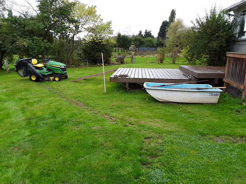
Poles like this white plastic pipe can help property owners measure how flood waters are rising or falling.
Mike bookmarked the Flood Authority’s link for the Newaukum River gage near Chehalis located about two-thirds of a mile downstream from his property, so he can quickly access gage data from his computer or cell phone.
Through years of experience understanding the relationship between rising water levels and gage information, Mike knows if water levels reach 202 feet, access in and out of his property will be blocked. At 203 feet, flood waters will be at his outbuildings but at 204 feet, water will be in his outbuildings. And at 206 feet, flood waters will be near the top of his deck.
The highest Newaukum River gage reading to date occurred during the historic 2007 flood when waters reached 205.39 feet, but the 1996 and 2009 floods also crested at roughly the same level.
Our CFAR technical advisers can help households know which river gage would best inform their individual situation and to understand how different water levels could affect their dwellings and properties.
Know what actions to take
After signing up for the Chehalis River Basin Flood Warning System alerts, bookmarking the appropriate gage site, and monitoring river and weather predictions, households should consider developing a checklist that includes when gage predictions mean access in or out of their property will be blocked.
Here’s a checklist of things to consider:
- Get all vehicles to high ground
- Call neighbors who may not be monitoring gage readings
- Consider leaving rather than riding out the flood. This is particularly important for properties on the Chehalis River main stem and other large rivers where water levels may stay up for a day or more; you don’t want to be isolated if you have an emergency
- Double check your “go kit” — a bag or case with all the things you need to take with you, such as your medications, insurance policies, and food for your pets. The Red Cross calls these Survival Kits (www.redcross.org/get-help/how-to-prepare-for-emergencies/survival-kit-supplies.html) while the Federal Emergency Management Agency labels them Ready Kits (https://www.ready.gov/kit)
- Check that items needed for your flood response, such as sand bags, are available and ready for use
Mike knows the first flood crest predictions are not always accurate. In January 2021, waters went 1.5 feet higher than first predicted. To be safe, he will usually implement most of his response measures, including those for river stages higher than predicted.
Identify actions to take before flood waters reach your property
Mike uses wooden pallets to keep firewood from floating away.
- Identify items like the barbecue grill that could get damaged or float away
- Move damageable items that can be moved to a higher location
- Tie down or secure items that can’t be moved
- Sandbag low points where water could enter a building, such as a window well
For instance, if the Newaukum River gage predicts a crest of 203 feet, Mike starts moving lighter, portable items to higher locations. His stack of firewood is secured by wooden pallets so it doesn’t float away. To protect his riding mower, he moves it onto his deck, which is higher than the largest flood on record. Mike also gets out his rowboat and ties it to a cleat on his deck. If his property is inundated, Mike can monitor conditions on his property or leave, as long as the water isn’t moving too fast.
Ascertain what to do if flood waters get into buildings
The best way to reduce or avoid flood damage to buildings before a flood is to move them to a higher location, elevate them, or implement other property protection measures.
Mike keeps his washer and dryer elevated to stay dry.
In addition, unless a dwelling or building has been structurally flood-proofed, it is best to assume water will get in. If a home has a basement, it’s actually best not to attempt to keep water out because the walls and floor may crack or break due to water pressure on the outside walls.
Here’s a list of things to consider:
- Identify damageable items that can readily be moved to higher locations, such as smaller carpets and furniture
- Determine where the items can go, such as upstairs or on top of a table or counter
- Elevate damageable items, such as the washer and dryer
- Elevate damageable utilities, such as the furnace and water heater
- Consider renovating flood-prone areas to minimize damage
- Consider renovating flood-prone areas to make clean up easier. For example, replace a wooden floor with a concrete floor. Use batt — or pre-cut panels — of insulation and don’t tape or paint the lower levels of wallboard. Instead, put the wallboard in with screws so the walls can be easily opened and the insulation removed before water wicks to a higher level
Mike has raised his electrical outlets to keep them high and dry during a flood.
More ideas on preventing flood damage and emergency flood protection measures can be found at Louisiana State University’s AgCenter site.
Requesting CFAR technical assistance and more information
If you are a property owner or business owner in the basin: to request initial technical assistance, if you need help developing a project, or have general questions about flood issues, please email Cindy Bradley or call 360-791-3488.
CFAR also provides technical support to local and tribal governments. In fall 2020, our Office of Chehalis Basin sponsored several floodplain management workshops and webinars targeted at basin city and county permitting officials, elected officials, and the general public. View agendas, presentations, and references for the workshops and webinars, which include detailed information about FEMA’s National Flood Insurance Program.