Chehalis Basin Long-Term Strategy
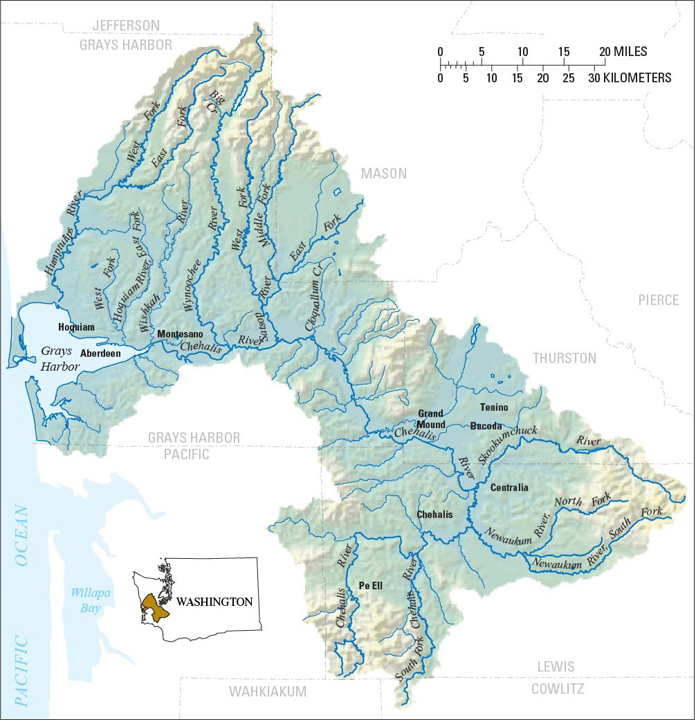
The Chehalis Basin. Click the image to enlarge.
The Chehalis Basin is a 2,700 square-mile river drainage system located in Southwest Washington along the Chehalis River and its tributaries. It is the second-largest river basin in Washington, flowing from the Willapa Hills and the hills east of Chehalis and Centralia, past the Capitol State Forest and Olympic Mountains into Grays Harbor.
In 2016, the Legislature created the Office of the Chehalis Basin to aggressively pursue an integrated Chehalis Basin Strategy to:
- Reduce flood-related damage within the basin.
- Restore and improve aquatic species habitat.
An integral part of the Chehalis Basin Strategy is the Chehalis Basin Board, who oversees implementation of the Strategy. The Board has seven voting members representing tribes, the Basin’s local flood authority, agricultural, environmental, and other community interests, and five ex-officio members representing state agencies. Together, we are looking at past, present, and future conditions in the Basin, including the effects of climate change.
Chehalis Basin Strategy projects
The Office of Chehalis Basin, Department of Fish and Wildlife, and the Chehalis Basin Board have been working together to perform studies and implement projects that protect communities from the effects of flooding, and to protect and enhance aquatic habitat within the basin. We have created an interactive storymap that details these projects, their status, and the investment of public funds. It also highlights some of the recent work done and upcoming projects.
Reducing damage from flooding
Over the past few decades, peak seasonal flood levels have been rising — with five of the basin's largest historical floods occurring during the last 30 years. Besides the 125 mile-long Chehalis River which flows into the Grays Harbor estuary on the Pacific Coast, the Chehalis Basin also includes the Black, Elk, Hoquiam, Humptulips, Johns, Newaukum, Satsop, Skookumchuck, Wishkah, and Wynoochee rivers, and their tributary streams.
In 1996, 2007, and 2009, the cities of Chehalis and Centralia experienced major flooding that caused millions of dollars in property damage and closed U.S. Interstate 5 (I-5), area highways, and rail lines for several days.
Flood reduction projects and planning
Flooding has always been present in the Chehalis Basin due to its wide, flat topography. But as the climate changes, catastrophic floods are no longer an isolated incident, with 100-year floods happening with increasing frequency. The Chehalis Basin Strategy will help prepare the region through both local and large-scale flood damage reduction actions. The Strategy also actively supports restoring habitat for native aquatic species, including salmon, steelhead, and amphibians.
Large scale flood damage reduction
Several options for large-scale flood damage reduction and protection against future flooding events have been evaluated or are currently under review.
Projects or actions that have been previously evaluated and determined to have feasibility concerns include:
- A large-scale restorative approach to decrease flood damage by moving large groups of people and structures out of harm’s way, and increasing the flood storage capacity of the watershed
- Smaller-scale restorative approaches for localized flood damage protection that also provide habitat improvements are still under active consideration.
- Raising, rerouting, or walling off low-lying portions of U.S. Interstate 5 (I-5).
Projects still under consideration include:
- Improvements to the Chehalis-Centralia Airport levee
- The North Shore levee to protect portions of Aberdeen and Hoquiam
- A flood protection dam and temporary reservoir proposed on the upper part of the Chehalis River
Currently, the proposed Chehalis-Centralia airport levee and flood protection dam are under formal environmental review. Learn more about this proposed flood damage reduction project and the environmental review process.
Local and community-scale projects
To reduce damage from flooding, we have launched the Community Flood Assistance and Resilience (CFAR) program. The program will help fund small scale projects in the Chehalis Basin focused on reduing future flood risks and flood damage to individual homes, businesses, and community assets, and addressing or resolving existing risks on an individualized basis.
Other actions being considered include:
- Local flood mitigation projects to protect infrastructure and reduce local-scale flood damage
- Improving flood warning systems
- Working with willing landowners on relocating vulnerable structures and repurposing areas near rivers and streams to improve floodplain function and prevent future flood damage
More than 100 local projects to limit or avoid flood impacts on people and property and to help salmon and other at-risk aquatic species have been completed or are currently underway.
Restoring and improving aquatic habitat
The Chehalis Basin is uniquely fertile with abundant wildlife. It is one of the few major river basins in Washington without any federally-listed endangered salmon, and has the highest diversity of amphibian species anywhere in the state. The basin supports various fish species including salmon, steelhead trout, lamprey, and the Olympic mudminnow.
However, the basin's ability to support some types of fish has been greatly diminished. Poor returns have significantly limited harvests for tribal and non-tribal fisheries. If aquatic habitat in the basin does not improve, salmon and steelhead could become endangered, along with other important species.
Aquatic species restoration planning
Current estimates indicate that within 60 years spring-run Chinook salmon and steelhead populations within the Chehalis Basin could be on the brink of extinction if nothing is done to improve and restore essential habitat. The Chehalis Basin Strategy identifies potential improvements to the Chehalis River and its tributaries in the Aquatic Species Restoration Plan (ASRP).
This plan takes into consideration both current issues, and future issues related to climate change. It was designed to efficiently and effectively rebuild and protect a productive ecosystem that is resilient to the impacts of climate change.
The ASRP reflects diverse interests across the basin including land owners, farmers, local governments, conservation groups, state agencies, tribes, and federal agencies. This basin-wide collaboration will help solve multiple challenges with efficient investments in land protection, restoration, and community planning, and achieve more than any agency, government, or group of citizens could do alone.
Effects of climate change
Due to climate change, we expect the trend of larger, more frequent winter flooding events to continue. Summers are also becoming hotter and drier, with droughts becoming more frequent in the basin. This creates the potential of low-water events and decreased stream flows that can affect fish and aquatic species due to higher water temperatures, loss of habitat, and lower oxygen levels.
Low water also affects farms and water users in the Basin. To protect those with senior water rights and stream flows for fish, junior water-right holders on the Chehalis River had their water use curtailed each year between 2014 and 2019.
Working with residents, local governments, and tribes
Along the 125-mile Chehalis River and its tributaries, there are many different counties, cities, and tribal governments, as well as landowners, farmers, environmental groups, and businesses, all with interests in improving the Chehalis Basin. The Office of the Chehalis Basin was created to bring all parties to the table and create a collaborative process to address the many challenges they face.
The Chehalis Basin Board is comprised of representatives from local and tribal governments, state agencies, and Basin agricultural, environmental, and economic interests to present a diversity of opinion and experience.
Related links
Contact information
Jeff Zenk
Director
jeff.zenk@ecy.wa.gov
360-338-5864
Stevie Colson
Executive Assistant to the Director
stevie.colson@ecy.wa.gov
564-669-4432


