

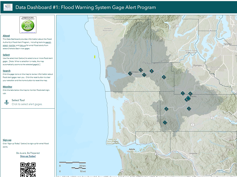
Flood season is here, and to help communities better prepare, the Chehalis River Basin Flood Authority recently launched its Flood Warning System Gage Alert data dashboard, which provides tools to search, sign up for, and monitor gage alerts.
Before this data dashboard, anyone interested in receiving email alerts — emails that tell you when nearby gages are at or are forecast to be at flood stages — had to sign up by emailing the Flood Authority with number of the gage alert in which they were interested. Now users can easily select gage alerts of interest and sign up online. Dashboard users can also provide feedback on the Flood Authority’s activities and products, such as its Flood Warning System, local projects, and outreach materials.
The major objectives of this dashboard are to ease the alert sign-up process for community members, mitigate risk, reduce flood-event recognition time, and increase response time. The dashboard allows people to make their own plans for when and how to evacuate.
“This really is your system,” said Scott Boettcher, staff of the Flood Authority, during a November 2022 presentation on the warning system. “This dashboard and the Flood Warning System were originally funded by the state capital budget, but it’s really maintained by the local governments in the basin. So, the three counties and some of the cities, they pay the cost of maintaining this system."
During a high-water event, sensor data trigger automatic email alerts about rising river levels. No. 5 is installed at the Skookumchuck River in Centralia. 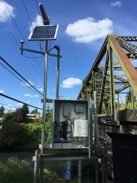
“This is an information system and a first line of defense. Having early information makes you aware so you can be prepared,” Boettcher said.
The basin has had a long history of both catastrophic and major flooding, with epic flooding in 2007 and 2009. In 2022, the basin had a series of events that culminated in record and near-record flooding. In early January 2022, communities throughout the Chehalis River basin experienced the worst flooding they’ve seen in more than a decade. The Newaukum River set a record height by nearly a half-foot.
The forecasting feature and high-water alerts portions of the flood warning system are important to everyone living in the basin, but the alerts are especially helpful to anyone in harm’s way, like farmers. In the 2007 and 2009 events, farmers suffered severe damage from high water, including damage to their equipment, buildings, feedstock, and, most sadly, their livestock. As a result, a simple solution was for farmers to create elevated areas — known as farm pads — that would rise above the potential flood elevations. They could then drive their livestock and equipment to these pads to keep them safe from floodwaters. The system’s high-water alerts help trigger when farmers need to respond and start moving equipment and animals to these safer areas.
We increasingly need to be prepared for the impact of climate change and the occurrence of these extreme events. The Flood Warning System and the sign-up data dashboard are ways for relatively fast adaptation to the changing climate around us, and they give us more information to better prepare for the increasing frequency of the flooding events that will occur in the future.
Have a question or comment about the data dashboard? Please reach out to Scott Boettcher, Chehalis River Basin Flood Authority staff, at scottb@sbgh-partners.com or 360-480-6600.