

This post follows Ecology’s latest update documenting the environmental investigation at the DTG-Anderson Landfill in Yakima, where we’re looking into potential contamination.
Earlier this year, DTG Recycle discovered high temperatures in a localized area beneath the landfill’s surface, indicating an underground fire in that spot. As DTG continues responding to the fire with regulatory oversight, the fire remains controlled with no signs of additional hazards.
The Yakima Health District and Ecology continue to address the situation, most recently by gathering new thermal data.
Thermal imaging is one type of tool to assess landfill fires and determine if additional investigation is needed, though this technology does have its limitations. Thermal imaging may be affected by time of day, other sources of heat, type of surface material, light, and distance.
How we took photos
We flew a thermal drone over three areas on site that needed closer observation. At each spot, we took two photos: one on the visual spectrum and one on the thermal spectrum.
Each thermal photo is labeled with the highest and lowest temperatures recorded at the time of the photo. Cooler surface temperatures are shown in shades of purple, while warmer temperatures appear orange and yellow.
The thermal images are additional pieces of information that paint a fuller picture of the situation. They can confirm what we already know and may tell us where more data is needed. This helps us decide what action to take next to protect the air, soil, water, and people near the landfill.
Location 1: where the underground fire was first confirmed
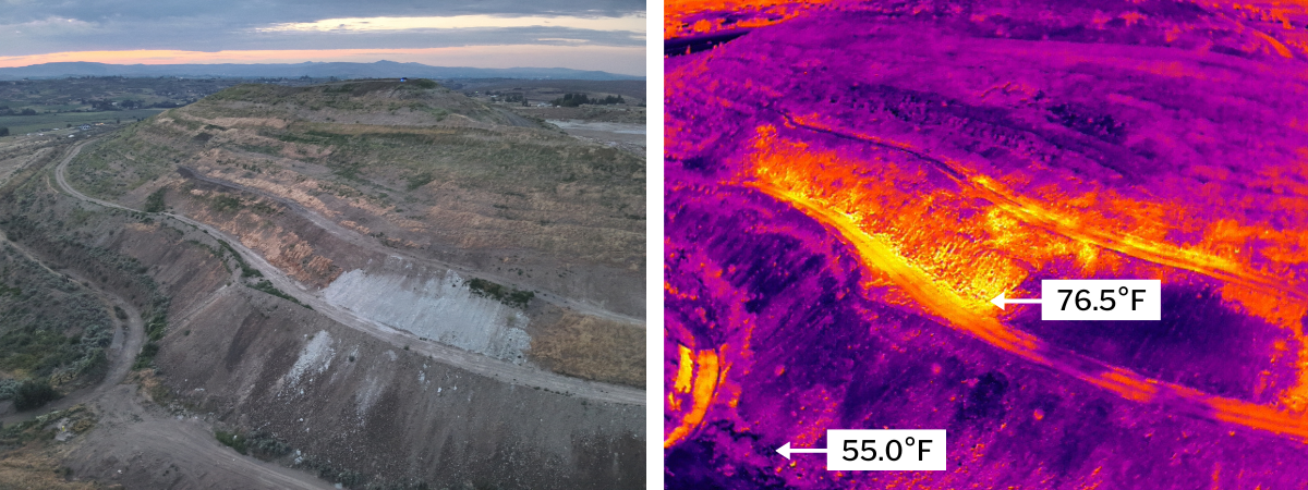
Most of the existing gas probes are installed here, where the underground fire was first confirmed.
The red and yellow areas in the middle of the thermal image indicate the likely location of the fire. To the right of the fire, the dark purple patch is where we first collected data about volatile organic compounds, or VOCs, emerging from underground.
We heard complaints about odors in the area and tracked the source to this spot. Our samples indicate that hazardous chemicals like benzene are in the gas emissions. In the normal photo on the left, you can see the white soil covering the area to help contain the emissions.
Location 2: heat detected on the south face
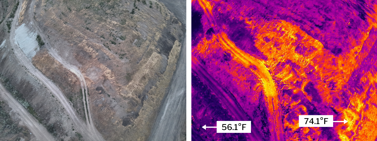
These photos were taken just south of Location 1 at the southwest corner. In the normal photo, you can see the white soil cover in the top left.
Previously, we used gas probe data to confirm that there is a subsurface fire on the left side of the photo. Our thermal imaging also indicated warm zones on the right side of the image, which is around the corner of the landfill on the southern face.
Because the thermal photo showed warm temperatures in this area — and because it’s near the fire we’ve already identified — gathering additional data would help us assess the extent of the fire.
Though there were no gas probes here when we inspected the area, DTG has since installed one on the southern face near the 74.1°F temperature reading. Data from this probe has not yet indicated there is a fire. Ecology, the Yakima Health District, and DTG are all continuing to monitor this area. We are also working with DTG to install more probes.
Location 3: heat detected in the landfill’s northeast corner
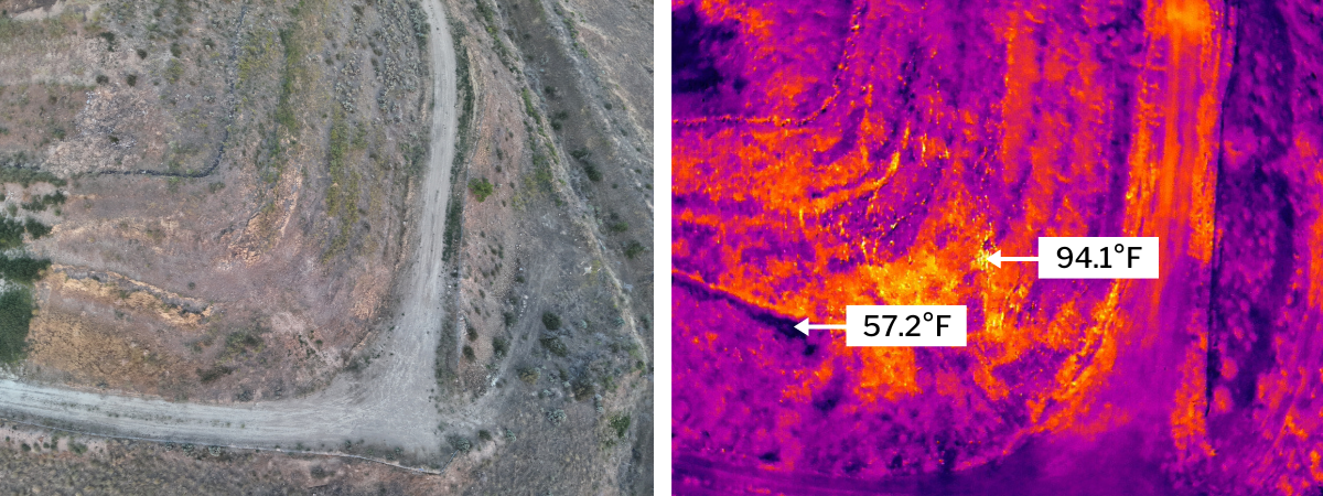
These photos were taken on the northeast corner of the landfill.
The thermal images indicate possible elevated temperatures. We observed surface cracks here that are similar to cracks we found at Location 1, where a fire has been confirmed. The temperature recorded here is hotter than any other recorded by the drone.
We’re working with DTG to collect additional gas data in this area, because there were no gas probes installed before taking these photos. There are now four gas probes here, and data from each is collected weekly. We are still monitoring to see if there is a fire here.
What’s happening now?
Extinguishing a landfill fire is a complex and potentially dangerous undertaking. Ecology and the Yakima Health District are overseeing DTG Recycle’s plans to put out the fire, with careful consideration of the safety of the landfill’s workers and surrounding community.
DTG’s current strategy, as advised by a landfill fire consultant, is to smother the fire with soil. Thermal imaging is one of the tools we are using to see if this plan is working, along with monitoring gas concentrations and temperatures.
The Yakima Health District is also conducting a comprehensive assessment of the fire. The agency is working with a dedicated fire consultant to analyze air emissions data, temperature readings, and field conditions. View the health district’s data report on its DTG Landfill webpage.
Additionally, DTG is preparing a cleanup workplan to identify and ultimately address the source of VOC emissions from the landfill. Our goal is to ensure the process is thorough and transparent, and we’re committed to informing you every step of the way.
Keep an eye out for future updates. View all documents and more information on Ecology’s Anderson Landfill cleanup webpage.