When streams and rivers run dry, the impacts ripple far beyond the empty riverbeds. Entire communities feel the strain. Farms struggle with irrigation, and vital habitats and fish migration pathways are lost. These are impacts that communities throughout the Walla Walla River basin know all too well. Map of the Walla Walla basin watershed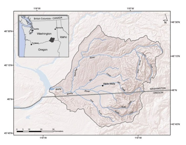
The Walla Walla basin extends into both Washington and Oregon, and crosses Tribal boundaries. The basin has a long history of challenges with water availability, including over appropriation of water rights, declining aquifers and reduced snowpack.
Strong partnerships and collaborative solutions, however, are making incredible headway. Plans are getting adopted and investments are being made that help meet the region’s water needs.
The work and newly minted partnerships are not without their challenges. A new, innovative program to protect bi-state water transfers this summer put it all to the test.
Managing water across state lines
With overwhelming support from local stakeholders, the Washington Department of Ecology was given authority in 2023 to enroll water rights from Oregon into Washington’s Trust Water Rights program.
Bringing together water rights holders from both states will help the partners focus on protecting water supplies in the greater Walla Walla River basin. This collaboration also allows water users to maintain sustainable supplies and help fish safely migrate to the upper reaches of the watershed.
As Brook Beeler, Washington Department of Ecology’s Eastern Region director explained, this first temporary water trust was a huge leap forward for the basin and will positively impact water needs into the future.
“The ability to enroll and protect water rights across state lines is a remarkable achievement and was widely supported by the community,” Beeler said. “The partnerships we’ve forged with Oregon, the Confederated Tribes of the Umatilla Indian Reservation, and local stakeholders is unprecedented in the northwest United States.”
However, some unexpected challenges arose as the new approach shifted water supplies between sources. The most visible was a creek running extremely low, and it caused significant concerns with neighbors that live along it.
Shifting water between Mill Creek and Yellowhawk Creek
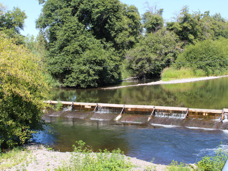
Earlier this year, Ecology enrolled an Oregon surface water right temporarily into trust from Aug. 1 through Sept. 30. The water right is typically used by the City of Walla Walla, but by keeping the water in the stream, it allowed water managers to maintain a minimum of eight cubic feet per second of water instream so fish could migrate through Mill Creek from the Walla Walla River.
More water in Mill Creek meant less water in Yellowhawk Creek. Historically, water was shared amongst two creeks. Because we directed the protected water down Mill Creek, community members living along Yellowhawk Creek noticed and voiced concerns about the lower-than-normal flows. During the first week of the water trust, the low flows caused more significant issues than anticipated.
After hearing from the community and investigating further, we discovered that the United States Geological Survey (USGS) stream gage we relied on to maintain water levels was incorrect. Once we confirmed water instream was more than double the gage reading, we immediately began diverting more water to Yellowhawk Creek.
“We regret that the first temporary water transfer did not go as smoothly as hoped,” Beeler said. “Hearing concerns directly from the community was and is an important step in the process for moving forward. I can assure you that we listened and are committed to improving our approach in the future.”
A commitment to success
Much thought and reflection are being put into planning efforts moving forward. For example, because of the USGS stream gage malfunction, we will confirm accurate streamflows on the ground prior to any future regulation.
We will also strengthen our partnerships and communication with habitat and fisheries managers to lessen impacts on creeks in the future.
Jerimiah Bonifer, Fisheries Program manager with the Confederated Tribes of the Umatilla Indian Reservation, explained that streamflows are the foundation to healthy ecosystems and healthy communities.
“We need innovative strategies to restore the stream flows of the basin, so we don’t continue to see our fisheries and communities suffer,” Bonifer said. “We are all in this together, and we will continue to push this unprecedented effort forward for the benefit of the basin and communities—both tribal and non-tribal—that rely on a healthy Walla Walla watershed.”
Mark Wachtel, Habitat Program manager for Washington Department of Fish and Wildlife Region 1, echoed this sentiment.
"We look forward to engaging with our partner agencies, as well as our other groups in the Walla Walla basin, to ensure that streamflow is maintained in important habitat areas at key times of the year," said Mark Wachtel. "We're committed to habitat improvement while balancing the needs of water users in the basin."
With the continued help of habitat and fisheries management, we can create more thorough and detailed approaches to decisions that will protect important stream reaches for fish and fish habitat.
Additionally, we are committed to increasing communication and outreach efforts on future trust projects, including drafting and adopting a developed water trust policy with public input to guide future decision-making.
Water for today, tomorrow and beyond
As we navigate the waters ahead, strong partnerships are essential to lasting water solutions in the Walla Walla River basin. Together, we will find new, innovative ways to secure a better water future for the region.