

Local emergency responder helps a resident in Sumas, Wash. during the Nov. 2021 floods in Northwestern Washington. Image courtesy Melanie Demerjian, all rights reserved.
Satellite image taken on Nov. 15, 2021. Image courtesy of NASA.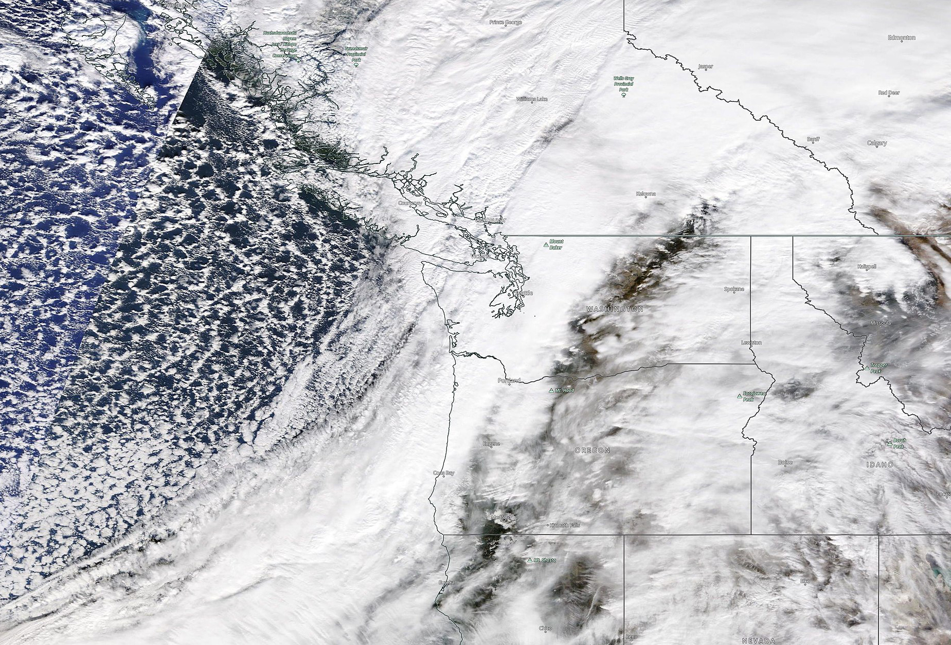
This has been a year of weather-driven extremes. In 2021, Washington experienced an unprecedented triple-digit heat wave, widespread summer wildfires, and record-setting drought conditions.
By November, dry weather gave way to rain. And then more rain.
For five days starting Nov. 12, a 2,500 mile-long column of moisture from the tropical Pacific Ocean — an atmospheric river — released a barrage of strong winds and torrential rain on Western Washington.
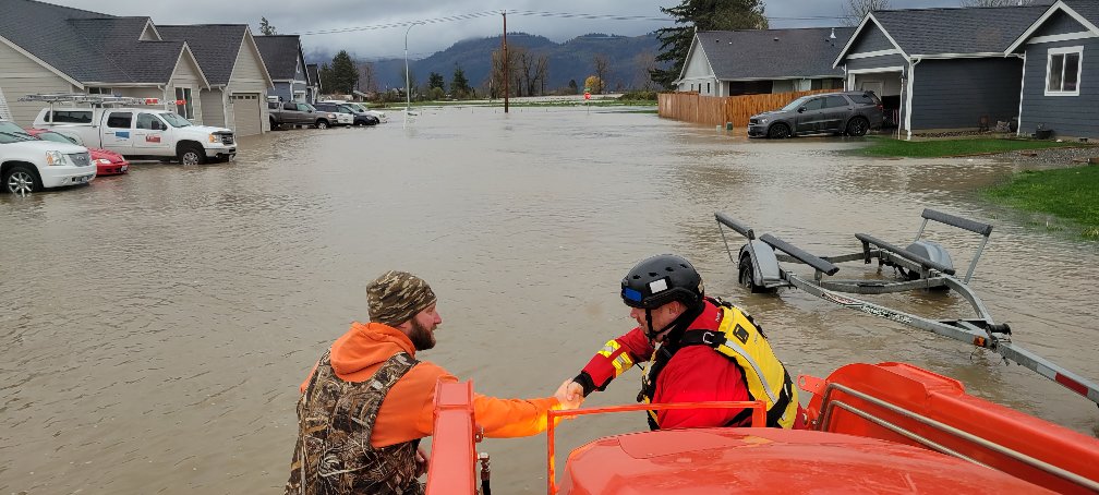
People being rescued from floodwaters in Sumas, Wash. Image courtesy Melanie Demerjian, all rights reserved.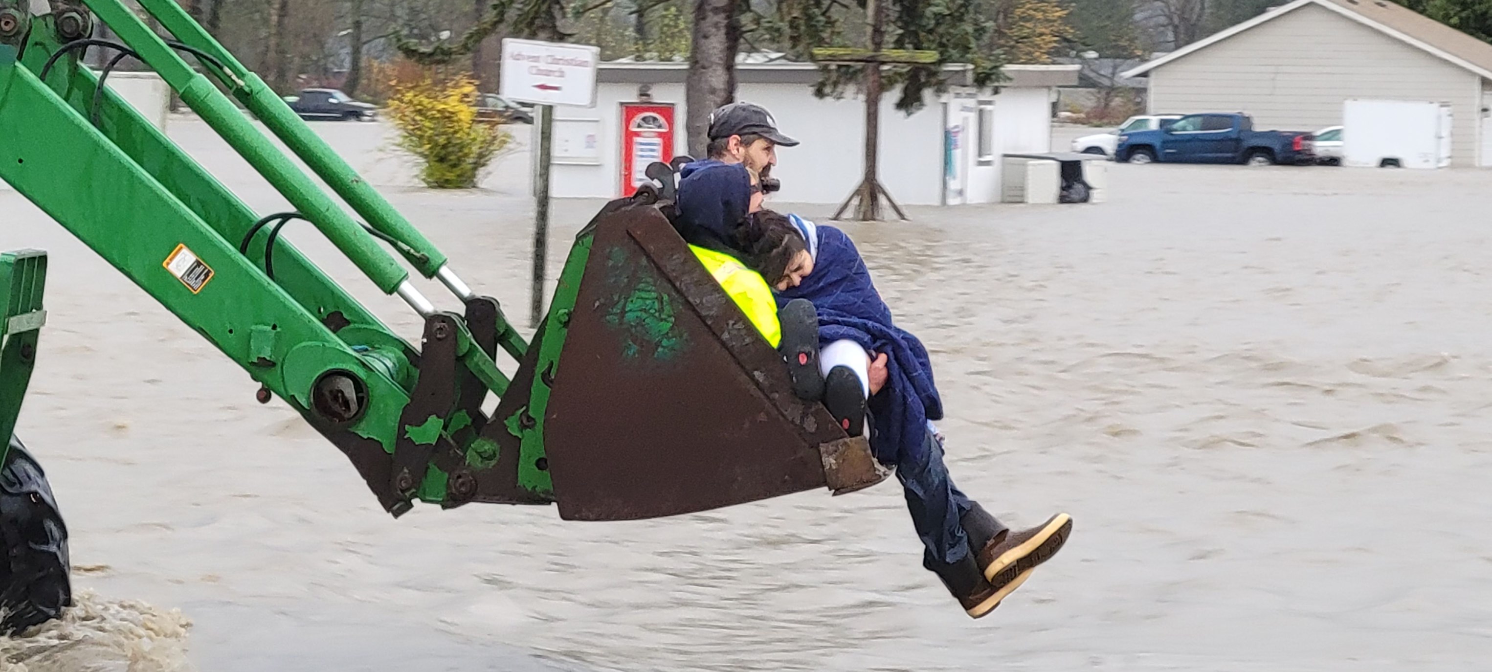
With rainfall totals reaching six inches or more, several rivers and streams overtopped their banks and hillsides gave way, unleashing mudslides from oversaturated soil.
Gov. Jay Inslee proclaimed a severe weather emergency for 14 counties. The Nooksack and Skagit river basins in Whatcom and Skagit counties were particularly hard hit by record-setting floods. In the town of Sumas, floodwaters damaged about 85% of the homes, businesses, and structures in the community.
During flood emergencies, Ecology supports local governments
Across Washington, the costs of flooding exceed all other natural disasters. In any given year, there is a better than an 80% chance that 10 or more flood events will occur, and the frequency of floods will increase as the climate changes.
Damage to railroads caused by flooding in Sumas, Wash. Image courtesy Melanie Demerjian, all rights reserved.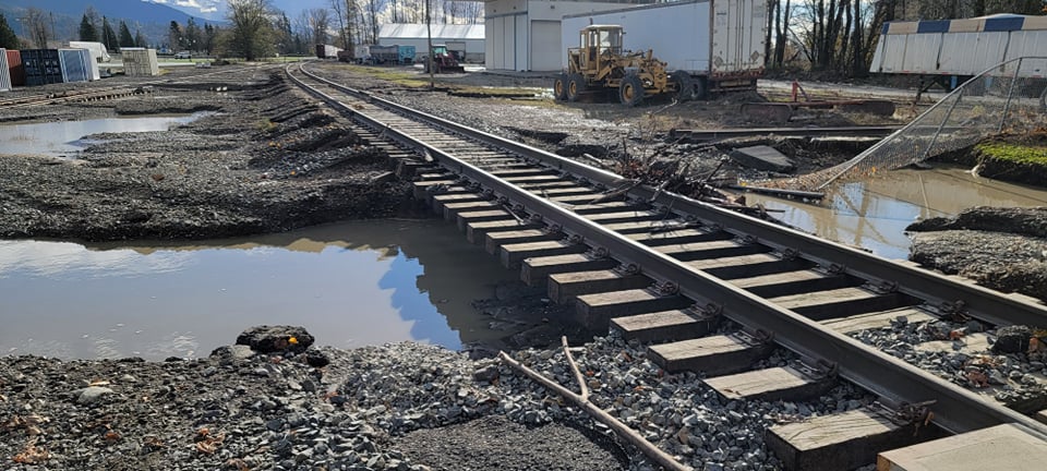
During a flood emergency, Ecology and other state agencies have a support but not a lead response role. In Washington, county governments generally have immediate responsibility for responding to flooding. Cities and counties can request response assistance from our Washington Conservation Corps (WCC) to help clear debris, operate pumps, fill and stack sandbags, and support other local response efforts.
On Nov. 15, for instance, Skagit County requested WCC assistance. Two WCC crews were deployed to Mount Vernon to help community volunteers fill sandbags. One crew helped build a 20-foot long sandbag wall to prevent water from damaging local railroad tracks. A third WCC crew helped fill sandbags in Burlington for people experiencing flood impacts.
At Clallam County and city of Forks’ request, we also deployed a WCC crew and two disaster response supervisors to the Forks area Dec. 9 to assess homes, help remove damaged materials from homes affected by floodwaters, and prepare each residence for mold treatment.
Floodwaters cover a local farm near Sumas, Wash. Image courtesy Melanie Demerjian, all rights reserved.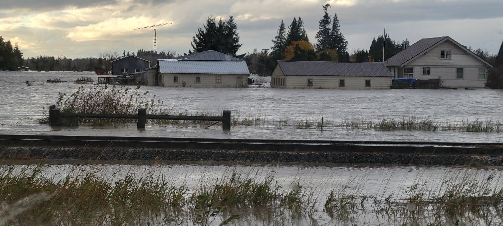
We can also provide local governments limited emergency funding for immediate actions to protect the environment. After Whatcom County experienced heavy rainfall compounded by historic flooding from the November storm, livestock manure storage facilities in Whatcom County experienced challenges storing manure in facilities such as lagoons and above-ground storage tanks.
To keep manure from being discharged to the Nooksack River — as well as nearby ditches and streams that flow to Birch Bay, Drayton Harbor, Lummi Bay and Portage Bay — we awarded a $20,000 Terry Husseman Account emergency grant to the Whatcom Conservation District. The conservation district will use the funds to help coordinate emergency manure pumping, hauling, storage, and application to manage storage capacity.
Floodplain management
While we do not directly respond to floods, we do help communities plan for, mitigate, and recover from flood damage. We lead floodplain management in Washington by providing technical assistance and grants to local communities to help them better plan within a floodplain. We also work with local and Tribal governments to help reduce life and property losses, and protect the natural environmental functions and values of floodplains.
An eagle catches a wayward salmon in a flooded pasture. Image courtesy Timothy Demerjian, all rights reserved.
Floodplains benefit people and the environment. Fertile habitat and arable farmland is often plentiful in healthy floodplains. Frequent flooding brings new sediment, creates meandering channels, and deposits woody debris and nutrients.
Floodplains also slow the flow and provide oxbows and wetlands that can soak up and store floodwaters. Think of them as shock absorbers — on your car they absorb excess energy smoothing out the ride. In a floodplain they absorb excess water and energy from floods, slowing their intensity and advance.
Planning grants help reduce community flood risks
More than 35 years ago, the Washington Legislature established the state Flood Control Assistance Account Program (FCAAP) to help local and Tribal governments develop comprehensive flood-hazard management plans to prepare for and reduce flood risks to local roads, bridges, and utilities while protecting the value of public and private property.
Train cars derailed by local floodwaters. Image courtesy Timothy Demerjian, all rights reserved.
Preparing for and avoiding flood damages is particularly important because storms are increasing in strength and frequency and sea levels are rising. It is also cost effective. Responding to a flood emergency often costs four to seven times more than investing in preventative measures, which saves about $6 for every $1 spent.
Flood hazard planning grants help communities preserve and protect salmon and important habitat areas. Local and Tribal governments completing plans also will be in a better position to compete for federal and other state grants to build better flood resiliency. This month, we awarded $1.5 million in flood hazard planning grants to:
- Chelan County Public Works Department ($112,500)
- Columbia County Flood Control Zone District (115,500)
- Cowlitz County Department of Building and Planning ($231,375)
- Jefferson County Community Development ($150,410)
- King County Water and Land Resources Division ($218,085)
- Kittitas County Public Works Department ($150,000)
- Mason Conservation District ($187,495)
- Snohomish County Conservation and Natural Resources Department ($155,502)
- Wahkiakum County Public Works ($43,133)
- Yakima County Public Services Department ($165,000)
Reducing flood risks in the Chehalis River basin
Our Office of Chehalis Basin is working to help restore and protect aquatic species habitat while also reducing damages from major floods in the Chehalis River basin in Southwest Washington. To put the two-pronged Chehalis Basin Strategy in place, we work closely with the Chehalis Basin Board, other local, Tribal, and state leaders, and local salmon recovery groups.
The Chehalis Basin Strategy’s collection of near- and long-term actions as well as small- and large-scale projects is vital because the 2,700 square-mile drainage basin is at a turning point. For decades, peak seasonal flood levels have been rising — with five of the largest historical floods occurring during the last 30 years.
Since 2015, we have helped direct $50.1 million in local and state funding for 38 flood-hazard reduction projects and invested $740,000 to establish evacuation routes and install reusable, elevated farm pads at 22 basin locations.
Community Flood Assistance and Resilience program
The Chehalis River meandering through fields next to I-5 in Centralia.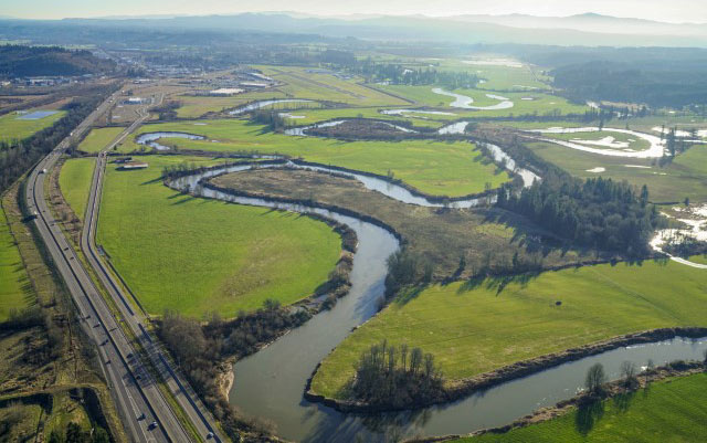
To reduce flood-related damage in the Chehalis River basin, we established the Community Flood Assistance and Resilience (CFAR) program in 2020 to help fund small-scale projects designed to prevent flood-related damage to homes, businesses, and community assets.
CFAR helps interested property owners and communities identify opportunities and set priorities for accessing program funding. CFAR also provides no-cost technical support to local and Tribal governments who participate in the National Flood Insurance Program (NFIP). Support activities include flood preparedness and response education, trainings and workshops, and supporting communities identify opportunities and priorities for future CFAR funding.
People and businesses in the Chehalis basin are also eligible for technical assistance, including no-cost site visits with technical advisors. Our specialists help:
- Answer questions and give advice about NFIP, including insurance rates.
- Explain how current and predicted river gauge readings during flood conditions relate to flood levels on specific properties.
- Pinpoint the most cost-effective ways to protect dwellings and structures during floods, based on site conditions and types of flooding.
- Landowners, business owners, and renters develop projects that may be eligible to apply for future CFAR funding.
Floodplains by Design
A flooded home in Sumas, Wash. Image courtesy Timothy Demerjian, all rights reserved.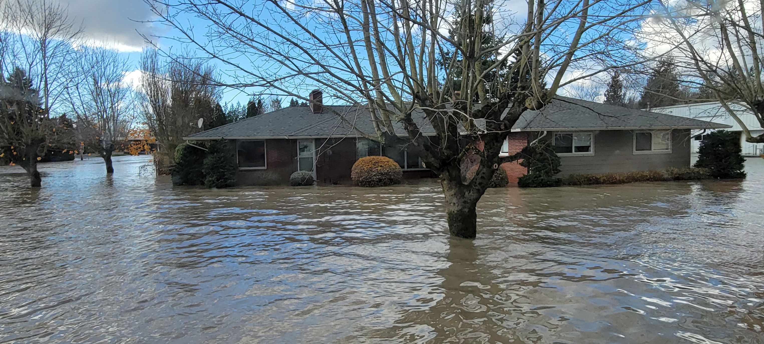
Floodplains provide important habitat for salmon, rich soil for farms, and beautiful backdrops for Washington residents. In the past, attempts were made to control rivers, thinking flooding could be stopped by walling off rivers with levees, straightening them, and laying out a grid of commercial and residential development across them. Now salmon runs are disappearing and more people live in the path of dangerous floodwaters.
Our Floodplains by Design (FbD) grant program is a modern public-private partnership co-managed with The Nature Conservancy and Bonneville Environmental Foundation. FbD is focused on re-establishing floodplain functions in Washington’s major river corridors. The program helps protect residences, farms, and businesses at risk from catastrophic flooding while restoring natural floodplain functions and aquatic ecosystems and habitat. Since 2013, we've invested $213 million for 45 FbD projects in 15 major floodplains located in 16 counties across the state.
The FbD program creates partnerships with Tribal governments, local floodplain managers, and farmers to design ways to return rivers and floodplains back to more natural conditions. FbD projects have included removing or setting back levees and other structures, planting native vegetation, building side channels for flood storage, placing engineered logjams in strategic locations, and improving agricultural drainage. Besides creating 2,755 new jobs over the past eight years, FbD projects also have:
- Reconnected 7,217 floodplain acres
- Restored, protected or improved 50 miles of river habitat
- Removed 434 residences and structures from high risk floodplain areas
- Reduced flood risks for another 2,212 homes and structures
- Protected and improved 9,177 acres of working lands
- Helped create or improve 25 public areas
Reducing flood risks, improving floodplain habitat
While Mother Nature’s fury cannot always be stopped, with proper planning and investments, it can be softened and redirected. Our grants and direct technical assistance help communities across Washington update their flood planning practices to co-exist with flooding — to mitigate and manage rather than trying to prevent it. This work brings residents, local and Tribal governments, farmers, fish recovery and conservation organizations together —t o plan for development, protect floodplain functions, and restore and preserve aquatic habitat.